
NEW PUBLICATION: Delaminating the Marine Atmospheric Boundary and Saharan Air Layers: Observations and modeling by MAGPIE to understand marine boundary and lower free troposphere layer inhomogeneity over the Northwest Tropical Atlantic
AUTHORS:
Reid J.S., Cossuth J.H., Gaston C.J., Holz R.E., Richter D.H., Sealy A., Thompson E.J., Wang Q., Chinita M.J., Dunion J.P., Eleuterio D.P., Marais W.J., Rubin J.I., Rushley S.S., Shen L., Wang Z., Yamaguchi R., Blades E., Bucholtz A., Buckholtz Z., Chewitt-Lucas R., Doyle J.D., Eck T.F., Eloranta E., Flagg D.D., Fu D., Garcia J.P., Hlywiak J.A., Jackson C.R., Król S., Lind E., Mabrey A., Malinowski S.P., Maring H.B., Melvin E.C., Miller M.A., Mittal S., Mulreany K.L., Razenkov I.I., Reid E.A., Roetman J., Ruiz-Plancarte J., Selmer P., Schmidt S., Shrestha S., Willitsford A., Witte M.K., Xian P., and Yuter S.E.
ABSTRACT:
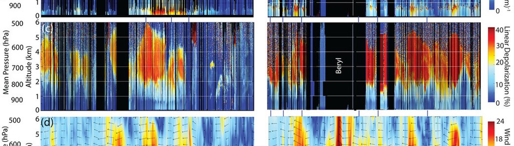
Simplifying the atmosphere into discrete layers, such as the marine atmospheric boundary layer (MABL) and its surface, mixed, and detrainment layers, as well as the Saharan air layer (SAL) aloft, is necessary in maritime meteorological modeling and data analysis. However, data reduction risks losing critical information. The Office of Naval Research (ONR) Moisture and Aerosol Gradients/Physics of Inversion Evolution (MAGPIE) experiment, centered on Ragged Point Barbados around August 2023, July 2024, and February 2025 used synthetic aperture radar (SAR), high-spectral-resolution lidar (HSRL), Doppler and Raman lidars coupled with ground-based instrumentation, and the Center for Interdisciplinary Remotely Piloted Aircraft Studies (CIRPAS)/NOAA aircraft to document the four-dimensional variability and large-to-fine-scale budgets of atmospheric state, clouds, sea salt, and dust. Results span three areas: 1) regime identification: SAR winds and geostationary imagery easily identify MABL regimes that can be reproduced in large-eddy simulations; 2) vertical exchange: Lidar and aircraft show that cloud organization of MABL regimes is related to vertical exchange from the near surface through cloud water vapor halos, especially at regime boundaries. Copious dust was also found in the MABL; and 3) SAL stratification: The concept of the monolithic or multilayer Saharan air is often realized as ultrafine Saharan air layer(s) stratified under influence by large-scale forcing, shear, diabatic heating, and likely more complex coupled processes. These insights inform multiscale modeling to bridge MABL “gray zone” processes too large for parameterization in large-domain models, yet too fine to be explicitly resolved due to computational constraints.
Significance Statement
While data reduction is necessary to analyze complex four-dimensional flows, oversimplification of atmospheric layers and their processes risks losing critical conceptual information and important model physics. The ONR Moisture and Aerosol Gradients/Physics of Inversion Evolution (MAGPIE) experiment deployed active remote sensing, aircraft, and shore-site instrumentation to capture the complex structure of the marine atmospheric boundary layer (MABL) and Saharan air layer (SAL). Findings reveal MABL cloud patterns are tied to vertical moisture exchange, significant dust exists within the MABL, and the SAL is a complex multilayer system, not monolithic. These crucial observations provide insights enabling refinement of multiscale models, more realistic simulations of airmass evolution, and significantly improved marine weather forecasts by bridging the gap between observations and “gray zone” modeling scales.
Originally published on - Oct. 2, 2026, 8:03 a.m.
Last update on - Oct. 2, 2026, 8:13 a.m.
Publisher - Sekretariat IGF